MMRI Geophysical, Drilling, and Laboratory Capabilities
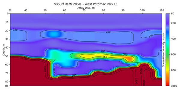
Seismic Refraction, Reflection, and Surface Wave Analysis
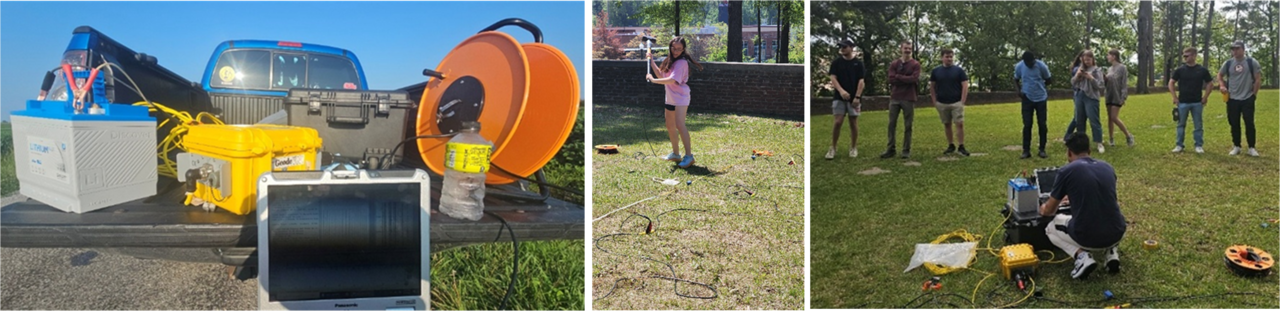
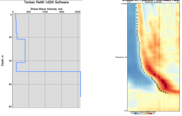
MMRI operates a 24-channel Geometrics Geode seismograph system equipped with 10 Hz geophones that can be deployed up to a 5-meter spacing. This versatile system supports a full suite of active-source seismic methods, including P-wave refraction for shallow velocity structure and depth-to-bedrock characterization, multichannel analysis of surface waves (MASW) for shear-wave velocity profiling, refraction microtremor (ReMi) for non-invasive Vs30 estimation in urban or access-restricted settings, and conventional seismic reflection for imaging subsurface stratigraphy. Together, these capabilities allow MMRI to address a wide range of engineering, environmental, and geologic investigations requiring high-resolution subsurface characterization.
Ground-Penetrating Radar
MMRI's ground-penetrating radar (GPR) capability is anchored by a Mala Ground Explorer system with three antenna frequencies, 80, 160, and 450 MHz, which provides flexibility across a wide range of investigation depths and resolution needs. The 450 MHz antenna delivers the finest spatial resolution and is ideally suited for shallow investigations such as utility detection, void identification, and near-surface stratigraphic mapping to depths of approximately 1–3 meters. The 160 MHz antenna offers an intermediate balance of resolution and penetration depth, commonly applied to investigations in the 2–10 meter range, while the 80 MHz antenna sacrifices resolution in favor of greater penetration, extending surveys to depths of 10 meters or more depending on substrate conditions. This antenna suite allows MMRI to tailor GPR surveys to the specific objectives of a given project, from archaeological and forensic investigations to geotechnical and environmental site characterization.
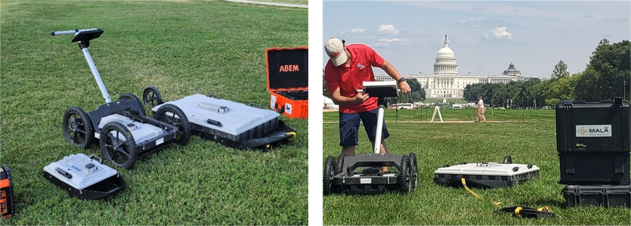
MMRI also operates an Impulse Radar CrossOver CO730, a state-of-the-art dual-channel GPR system that meaningfully extends and complements the capabilities of the Mala Ground Explorer. The CO730 incorporates two simultaneous acquisition channels operating at center frequencies of 70 MHz (low frequency) and 300 MHz (high frequency), allowing both penetration depth and stratigraphic resolution to be captured in a single pass across a survey line. This dual-channel design eliminates the need to resurvey the same transect with different antennas, reducing field time and ensuring that both frequency datasets share an identical spatial footprint.
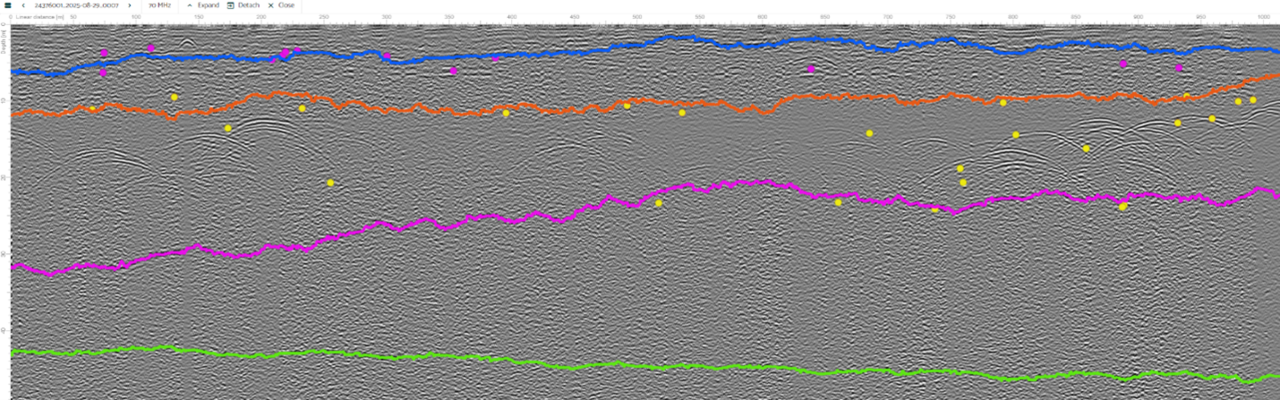
Data acquisition rates exceed 800 scans per second, and the system imposes no significant practical survey speed limitation under typical operating conditions, supporting collection rates greater than 130 km/h at a 5 cm point interval, making it particularly well suited for vehicle-towed transects across large study areas. The CO730's 70 MHz channel offers a time window of 2,500 ns, providing a maximum investigation depth that exceeds what is achievable with the Mala Ground Explorer's 80 MHz antenna, while the 300 MHz channel bridges the resolution gap between the Mala's 160 MHz and 450 MHz antennas. The instrument incorporates an integrated DGPS module and supports Bluetooth connections to external GPS receivers, and data acquisition is managed wirelessly through an Android tablet interface. Together, the Mala Ground Explorer and the CrossOver CO730 give MMRI a comprehensive GPR toolkit spanning the full range of frequencies most relevant to near-surface geologic, geotechnical, archaeological, and environmental investigations.
Terrain Conductivity
The Geonics EM38 MK1 is a single-frequency ground conductivity meter designed specifically for shallow soil and near-surface investigations. Operating at a fixed frequency of 14.6 kHz with a 1-meter coil separation, the EM38 MK1 measures apparent electrical conductivity and in-phase magnetic susceptibility in both horizontal and vertical dipole orientations, providing approximate effective depths of investigation of 0.75 meters and 1.5 meters, respectively. This shallow depth range makes the instrument particularly well suited for precision agriculture applications, soil salinity and moisture mapping, detection of buried objects or anthropogenic disturbances, and characterization of the uppermost soil horizon. The EM38 MK1's compact, single-operator design allows for rapid data collection along transects, and its output can be georeferenced using GNSS to produce spatial maps of near-surface conductivity variation.

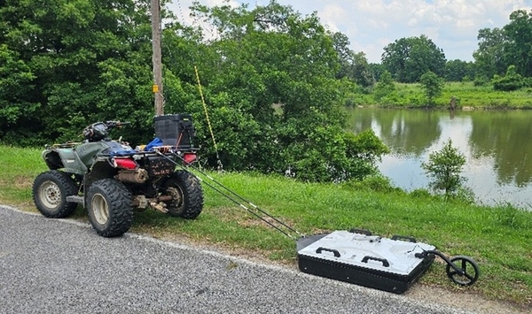
Frequency-Domain Electromagnetic Induction
The GF Instruments CMD Explorer 6L is a six-receiver, frequency-domain electromagnetic (FDEM) induction instrument that measures apparent electrical conductivity and magnetic susceptibility (in-phase) simultaneously at six discrete depths in a single pass, without requiring direct ground contact. The instrument operates by rotating the sensor probe between two orthogonal dipole orientations: in the vertical dipole (horizontal coplanar, or HCP) configuration, the instrument can simultaneously measure six effective depths of investigation: 0.9, 1.6, 2.4, 3.7, 5.0, and 6.3 m. Rotating the probe 90 degrees to the horizontal dipole (vertical coplanar, or VCP) configuration halves these depths, providing high-resolution coverage of the 0.45 to 3.15 meter intervals. This combination of HCP and VCP modes allows MMRI to construct a detailed multi-layer conductivity profile spanning from less than one meter to nearly 7 meters depth, effectively bridging the scale gap between the shallow vadose-zone sensitivity of the Geonics EM38 MK1 and the deeper investigation depths achievable with the ABEM Terrameter LS2.
Applications for the CMD Explorer 6L include rapid reconnaissance mapping of lateral and vertical variations in soil and sediment electrical properties, delineation of clay-rich or saline horizons, detection of buried anthropogenic features, groundwater quality assessment, and environmental site characterization. The instrument's contactless measurement principle makes it effective in very dry or frozen ground conditions where galvanic-contact methods fail, and its high sampling rate supports vehicle-mounted surveys over large areas. Data can be integrated with GNSS positioning to produce georeferenced conductivity maps and vertical section images, and the onboard software supports in-situ inversion for real-time depth interpretation in the field. MMRI has constructed a plastic drag-sled to collect long, continuous profiles with an ATV.


Electrical Resistivity Tomography
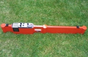
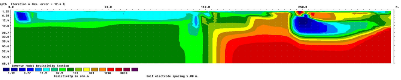
MMRI's electrical resistivity imaging (ERT) capability is built around the ABEM Terrameter LS2 multi-electrode resistivity system. The instrument is configured with two electrode cable sets: a 4x16 cable set supporting 64 electrodes at 5-meter spacing for investigations requiring greater lateral resolution, and a 21x4 cable set supporting 84 electrodes at 10-meter spacing for deeper or longer-profile surveys. The Terrameter LS2 supports a full range of electrode array configurations, including Wenner, Schlumberger, dipole-dipole, and gradient arrays, and is capable of automated data acquisition with real-time reciprocal error monitoring for quality control. With the 10-meter electrode spacing configuration, ERI surveys conducted with this system can resolve subsurface resistivity structure to depths of nearly 100 meters, making it one of the most capable tools in MMRI's geophysical inventory for investigations requiring substantial vertical penetration.
Applications span a broad range of geologic, environmental, and engineering challenges: mapping the geometry of aquifer systems and confining units; detecting faults, fracture zones, and lithologic contacts; characterizing the depth and lateral extent of saltwater intrusion or contaminated groundwater plumes; locating and delineating buried karst features, sinkholes, and voids; assessing the thickness and integrity of waste repository covers and liner systems; and supporting geotechnical investigations at dam, levee, and infrastructure sites. Because ERT produces a continuous two-dimensional cross-section of subsurface resistivity rather than a single point measurement, it is particularly well suited for tracing the lateral continuity of stratigraphic units and identifying localized anomalies that would be missed by borehole or surface sampling alone. The depth, electrode configuration flexibility, and data quality controls of the Terrameter LS2 make ERT a cornerstone method for MMRI's applied geophysical investigations.
Passive Seismic — HVSR and Structural Resonance
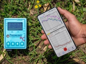
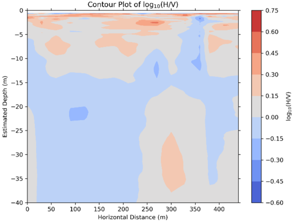
The MoHo Tromino Blue seismometer is a self-contained, three-component broadband seismometer designed for passive seismic acquisition across a wide range of field and structural engineering applications. MMRI uses the Tromino Blue primarily for horizontal-to-vertical spectral ratio (HVSR) measurements, in which the ratio of the horizontal to vertical components of ambient seismic noise is computed across the frequency spectrum to identify the fundamental resonance peak of a site. This peak frequency is directly related to the depth and impedance contrast of major subsurface boundaries, most commonly the interface between soft unconsolidated sediments and underlying bedrock or competent substrate, allowing the instrument to provide estimates of sediment thickness and site amplification potential without invasive drilling or active seismic sources.
Beyond subsurface characterization, the Tromino seismometer can be deployed for structural health monitoring and resonance frequency assessment of engineered structures. When placed on a bridge deck, building floor, or other structural element, the instrument records the ambient vibration response of the structure itself, from which the fundamental and higher-mode natural frequencies can be extracted. Knowledge of a structure's resonance frequencies is critical for evaluating vulnerability to seismic loading. If the natural frequency of a structure is close to the dominant frequency of ground shaking at a site, as determined independently by HVSR, the potential for resonance-driven amplification of structural response is significantly elevated and increasing the risk of damage during strong ground shaking. This coupled analysis of site and structural resonance is particularly valuable for aging infrastructure such as un-
reinforced masonry buildings, older highway bridges, and historic structures where design documentation may be incomplete or where significant changes in structural condition may have occurred over time.
The Tromino Blue is also capable of supporting multichannel analysis of surface waves (MASW) using ambient noise sources, extending its utility to shear-wave velocity profiling in environments where active-source methods are impractical. The instrument's compact form factor and self-contained data logger make it well suited for urban or environmentally sensitive sites where invasive methods or large equipment setups are not feasible.
High-Precision GNSS Positioning — Emlid RS2 and RS3
MMRI operates both the Emlid Reach RS2 and RS3 multi-band GNSS receivers, providing survey-grade positioning capability in support of geophysical field investigations. Both units support real-time kinematic (RTK) positioning and post-processed kinematic (PPK) workflows, achieving centimeter-level horizontal and vertical accuracy in the field. The RS2 is a dual-frequency receiver capable of tracking GPS, GLONASS, BeiDou, Galileo, and QZSS constellations, while the RS3 extends this capability with tri-frequency reception and enhanced performance in challenging multipath environments. These systems are routinely deployed to establish precise spatial control for geophysical survey profiles, including ERI transects, GPR lines, and seismic arrays, ensuring that subsurface data can be accurately georeferenced and integrated with GIS and other spatial datasets. The combination of RS2 and RS3 units allows MMRI to configure base-rover RTK pairs entirely from in-house equipment, without reliance on external reference networks.
Drilling
MMRI operates a truck-mounted Giddings (Model 25-SCT HDGSRPST) drill rig capable of supporting a range of drilling and direct-push coring methodologies. The rig is equipped with 100 feet of solid 3-inch augers for conventional rotary drilling, 25 feet of 3.25-inch hollow-stem augers for sampling unconsolidated materials while maintaining borehole stability, and 100 feet of kelly bars for direct-push continuous coring. This configuration allows MMRI to conduct stratigraphic sampling, geotechnical borings, and continuous core recovery in a variety of near-surface geologic settings. The truck-mounted platform provides the mobility necessary to access a range of field sites while retaining the mechanical capability required for investigations targeting Quaternary sediments and shallow bedrock. Cores and sediment samples recovered by the Giddings rig are processed and analyzed in MMRI's Sediment and Core Analysis Laboratory, where the full suite of physical, textural, mineralogical, and imaging analyses described below can be performed. This integration of field drilling capability with dedicated laboratory infrastructure allows MMRI to carry investigations from sample acquisition through quantitative characterization within a single institutional framework, reducing turnaround time and maintaining chain-of-custody control over recovered materials.

Vibracoring
MMRI has access to the Department of Geology and Geological Engineering’s Wink Vibracorer. The system includes 50 feet of both large and small diameter core barrels, providing the capacity to recover continuous sediment cores from soft to moderately consolidated sediments. Vibracoring uses high-frequency mechanical vibration to advance the core barrel with minimal sediment disturbance, making it the preferred method for recovering undisturbed stratigraphic sequences in fluvial, lacustrine, estuarine, and coastal environments. MMRI's vibracoring capability supports investigations of Quaternary sediment stratigraphy, paleoenvironmental reconstruction, and near-surface sediment characterization in settings where conventional rotary drilling would be impractical or destructive to the sedimentary record. Cores recovered by the vibracorer are well matched to the analytical capabilities of MMRI's Sediment and Core Analysis Laboratory. The undisturbed nature of vibracored material is particularly important for preserving the primary sedimentary fabric and magnetic signal required for reliable magnetic susceptibility measurements, laser particle size analysis, and high-resolution core imaging — analyses that depend on minimal post-recovery disturbance of the sediment column. The combination of vibracoring in the field and laboratory-based physical and textural characterization gives MMRI an end-to-end capability for detailed Quaternary stratigraphic and paleoenvironmental investigations.
Sediment and Core Analysis Laboratory

MMRI's Sediment and Core Analysis Laboratory provides a comprehensive suite of analytical capabilities for the physical, textural, magnetic, and visual characterization of sediment samples and continuous sediment cores. The laboratory maintains a fully equipped core splitting and description station, including all standard tools and reference materials for performing detailed sedimentologic descriptions — including Munsell color determination, lithologic logging, identification of primary and secondary sedimentary structures, and contact characterization — in accordance with established stratigraphic core description protocols.

The laboratory’s Horiba Partica 950-V2 laser particle size analyzer is capable of measuring grain size distributions across the clay, silt, and sand fractions (approximately 0.01 to 3,000 microns) using laser diffraction, providing rapid, high-resolution granulometric data without the labor intensity of traditional pipette or hydrometer methods. For coarser materials and quality control of laser diffraction results, a Ro-Tap mechanical sieve shaker is available for dry sieving analyses using standard phi-scale sieve series. A wet sieving station complements both instruments, enabling the separation and recovery of coarse fraction materials from fine-grained matrices and the preparation of samples requiring disaggregation prior to laser or mechanical analysis.

Magnetic susceptibility measurements are performed using a Bartington MS3 system, which quantifies the concentration and mineralogy of ferrimagnetic minerals within sediment samples and core sections. Magnetic susceptibility is a sensitive proxy for changes in sediment provenance, pedogenic intensity, and diagenetic alteration. The MMRI has 70 mm and 45 mm MS2C sensors for whole cores and a MS2K sensor for split cores for for both point measurements on discrete samples and continuous down-core logging at high spatial resolutions.
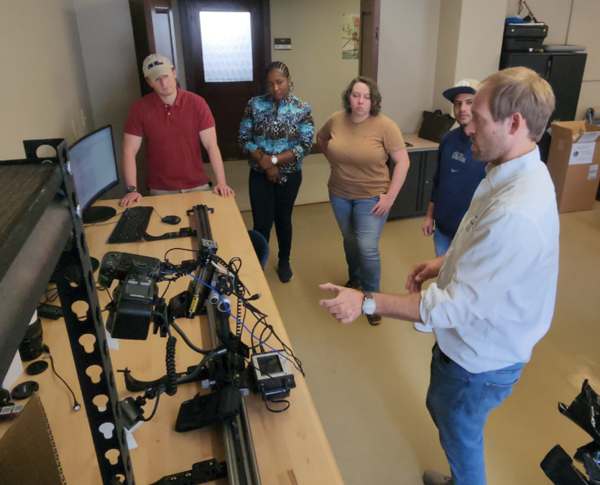
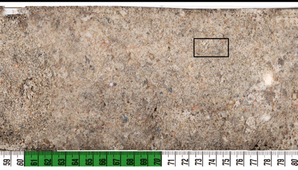
High-resolution visual documentation and imaging of core surfaces is provided by a Macroscopic Solutions Automated Macropod CoreScan focus-stacking system, which captures optically corrected, fully focused composite images of split core faces at macro-scale resolution. The focus-stacking capability eliminates depth-of-field limitations inherent in conventional core photography, producing publication-quality images that reveal fine-scale sedimentary structures, laminations, color variations, and textural features that would be difficult to document by eye or with standard photography. Together, these capabilities allow MMRI to support a full spectrum of core-based research from applied geotechnical investigations to high-resolution paleoenvironmental and stratigraphic studies.