Who we are

MississippiView is a member of the AmericaView consortium. advances Earth observation education through remote sensing science, applied research, workforce development, technology transfer, and community outreach.

MississippiView was established in 2003 and is led by the Geodata Analytics Laboratory (GDAL) at the University of Mississippi. We promote and facilitate geospatial data usage, research, and collaboration among the geospatial community in Mississippi while fostering national and international cooperation

High Impact Activity (HIA)

MississippiView brings benefits to the state of Mississippi:

• Supports research to investigate improved flood forecasting, disaster response and recovery, and enhanced methods of education.

• Applications using a variety of the spaceborne, aerial, and terrestrialbased sensors are taught to students of Mississippi and support applied research in the state.

• Ongoing projects in use of machine learning help to better monitor changes to land use which may affect the tax base and urban/development planning of a region.

• Outreach partnership with K-12 and professional educators provide opportunities to introduce remote sensing concepts and Earth Observation.

• MississippiView supports teaching curriculum and expanding our consortium to promote training future users and advancing the workforce in a changing world.

• All these examples and more go to contribute to the economic development in the state of Mississippi.


Groundwater level prediction of the Mississippi River Valley Aquifer (MRVA) for April 2013.

 One of our high impact activity (HIA) involved studying the use of machine learning (ML) algorithms for downscaling remotely sensed Earth observation data. In a world increasingly affected by climate change, there's a pressing requirement for high-resolution, continuous hydrological data to facilitate sustainable water management and predict water-related trends. The Gravity Recovery and Climate Experiment (GRACE) mission, since its launch in 2002 and its successor, GRACE-FO, has indeed transformed hydrological monitoring. By measuring the variations in Earth's gravity field, it provides crucial data on terrestrial water storage (TWS). Despite limitations in spatial and temporal resolutions, GRACE has proven invaluable in studying changes in groundwater storage and aiding in formulating long-term water management strategies.​

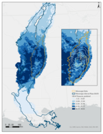
Key issues threatening the MRVA include:

• Since the late 1920s, water levels decreased by nearly half of its thickness

• Led to reductions in the baseflow of streams connected to the aquifer

• Formation of cones of depression in some areas, altering groundwater flow and potentially causing up-coning of brackish water

• Increased chloride concentrations in the aquifer, affecting water quality

Cleardiam accumsan l

Quis autem vel eum iure reprehenderit qui in ea voluptate velit esse quam nihi.

ipsam voluptatem

Ut enim ad minima veniam, quis nostrum exercitationem ullam corporis suscipit laboriosam.

ipsam voluptatem

Ut enim ad minima veniam, quis nostrum exercitationem ullam corporis suscipit laboriosam.

ipsam voluptatem

Ut enim ad minima veniam, quis nostrum exercitationem ullam corporis suscipit laboriosam.